Image at
the museum.
No image reuse licence has been verified. The museum’s catalogue remains the authority.
See the painting at the museum ↗Object research · Oliver Hazard Perry · Florence Griswold Museum · 2017.1.3
View of Stonington [CT], May 14, 1892, at 5am
14 May 1892 · Stonington, Connecticut · 5 a.m. in the title, “5 AM” in the inscription
“View of Stonington [CT], May 14, 1892, at 5am”
Title as given by the curator, 17 September 2026. P1 The place, date and hour are also inscribed on the front, lower right, in what the curator understands to be Perry’s hand. P6 Nephos reads the inscription, from her photographs, as “Stonington May 14 1892 5 AM”. P7 Each underlined phrase links to its claim.
Finding · Nephos analysis · version 2026-09-18
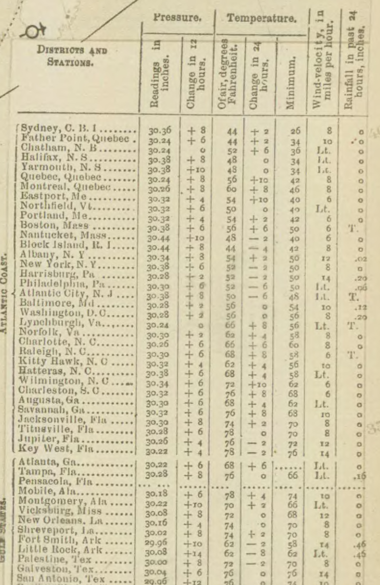
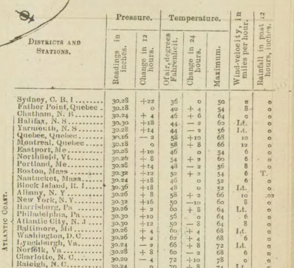
The morning map records cold air, no rain in the previous 24 hours and high, rising pressure at Block Island, about 35 km from Stonington. The reported minimum was 42°F; at 8 a.m. Eastern Standard Time it was 44°F with an 8 mph wind and no rain in the preceding 24 hours; the sky symbol is the map’s clear-sky mark. The barometer read 30.44 inches, up 0.08 inch in 12 hours, and the map places the high-pressure centre off that coast with the label “HIGH”. The Bureau reported that clearing weather had reached the north Atlantic coast. No observation at Stonington itself was located. Five o’clock was three hours before the 8 a.m. map under standard time, or about three hours twelve minutes before it under local mean time (clock time set by the sun at Stonington, about 12 minutes ahead of Eastern Standard Time). Calculations put five after sunrise under either clock, without establishing whether sunlight reached the scene.
The Nephos method
How this study was read
The method in fullWhat is written
Stonington, Connecticut, 14 May 1892, five in the morning: the curator’s title, and an inscription on the front in Perry’s hand as the curator understands it.
View of Stonington [CT], May 14, 1892, at 5am
Title as given by the curator, Florence Griswold Museum, 17 September 2026; not an inscription transcriptionStonington May 14 1892 5 AM
Inscription on the front, lower right; Nephos’s reading of the curator’s photographs, with the “AM” she pointed out on 25 September 2026
Records of those days
- U.S. Weather Bureau map, 14 May 1892, 8 a.m.Block Island, about 35 km away: 44 °F, minimum 42 °F, 8 mph wind, no rain in 24 hours, the clear-sky symbol.
- The computed sunSunrise at the assumed position: 4:29 a.m. standard time, or 4:42 a.m. local mean time.
Not found or not yet searched
- No observation at Stonington itself was located.
- The museum’s online catalogue could not be opened; the object fields come from the curator.
Each claim tested
- “Stonington [CT]”. The nearest station on the map is Block Island, about 35 km away; no easel site is established.
- “May 14, 1892”. A dated observation gives the morning’s context but cannot date the painting.
- “at 5am”. Five falls after calculated sunrise under either clock: about 31 minutes after under standard time, 18 under local mean time.
Verdict
The morning map records 44 °F, no rain in the previous 24 hours and high, rising pressure at Block Island, about 35 km from Stonington.
- Partially agrees“at 5am” Daylight is possible under both clocks; the hour of painting and the sun on the scene are not established.
- Unknown“Stonington [CT]” Named in the title and the inscription; no source establishes the painting position or view.
- Unknown“May 14, 1892” Inscribed in Perry’s hand, as the curator understands it; no independent record confirms the painting was made that day.
What this cannot tell you. The title contains no weather words, so this record gives no verdict about the painted sky. The map is three hours after five, and Block Island is not Stonington. The time verdict concerns possible daylight only.
01 · The evidence
A place, a day and an hour.
The title contains no weather words. There is no weather claim to confirm or contradict, and this record makes no verdict about the painted sky. The hour can be compared with calculated sunrise.
| Claim in the title | The curatorObject information · P1 | Morning weather mapBlock Island · 8 a.m. · P2 | The sunTwo clocks · P3 | Verdict · Nephos |
|---|---|---|---|---|
| “Stonington [CT]” Unknown | Stonington [CT] | About 35 km away. No Stonington reading on this map. | Assumed town position, not a verified easel site. | The title and the inscription name Stonington. No independent source located here establishes the exact painting position or direction of view. P1 Link to claim · Suggest a correction |
| “May 14, 1892” Unknown | 14 May 1892 | A dated observation provides context; it cannot date the painting. | Calculation conditional on the supplied date. | The date is inscribed on the front, lower right, in what the curator understands to be Perry’s hand, and matches the title. No independent record confirms that the painting was made that day. P1 Link to claim · Suggest a correction |
| “5am” Partially agrees | 5am; clock convention unspecified | Three hours later under Eastern Standard Time; about three hours twelve minutes later under local mean time. | Sunrise about 4:29 a.m. standard time or 4:42 a.m. local mean time. | Five in the morning falls after calculated sunrise under both clock conventions. This supports the possibility of daylight, but does not independently establish the hour of painting or the visibility of the sun. P3 Link to claim · Suggest a correction |
Described. The curator supplies the title. The place, date and hour are also inscribed on the front, lower right, in what the curator understands to be Perry’s hand. P6 A museum description of the scene has not been verified.
Measured and described. The Weather Bureau’s temperatures, barometer, wind speed and rainfall are instrumental records; “Cloudless” is the map’s descriptive symbol category, not a measurement. P2
Computed. Sunrise and the position of the sun follow from the assumed coordinates, date and clock. They are not observations of the sky or measurements of the painting. P3
The time verdict concerns possible daylight only. It does not establish when the painting was made. A painting is never treated as a weather measurement.
02 · The witnesses
A later coastal observation, and two possible clocks.
No observation at Stonington at the title’s hour was located in this search. Block Island is the nearest station identified on the morning map; a closer record may survive.
Measured and described · P2
Block Island at 8 a.m.
44°F air temperature
42°F reported minimum
30.44 in sea-level barometer
8 mph wind speed
14 May 1892, 8 a.m., 75th-meridian time (Eastern Standard Time). About 35 km from Stonington. P4
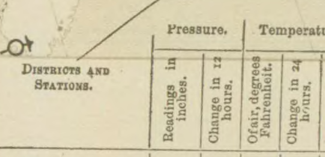
The table headings read “Temperature. Minimum.” and “Pressure. Readings in inches.” The reported minimum is 42°F. Under “Pressure. Change in 12 hours.” the printed “+ 8” means a rise of 0.08 inch, in hundredths. The preceding evening’s 30.36-inch reading confirms that scale. P5
The Bureau places the high-pressure centre off that coast with “HIGH” printed southeast of Block Island. Block Island symbol at 8× · Station comparison and the “HIGH” label. No wind direction is claimed.
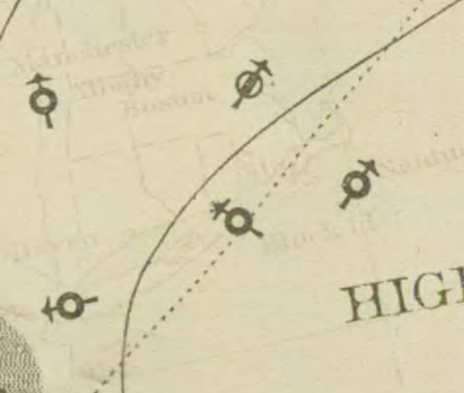
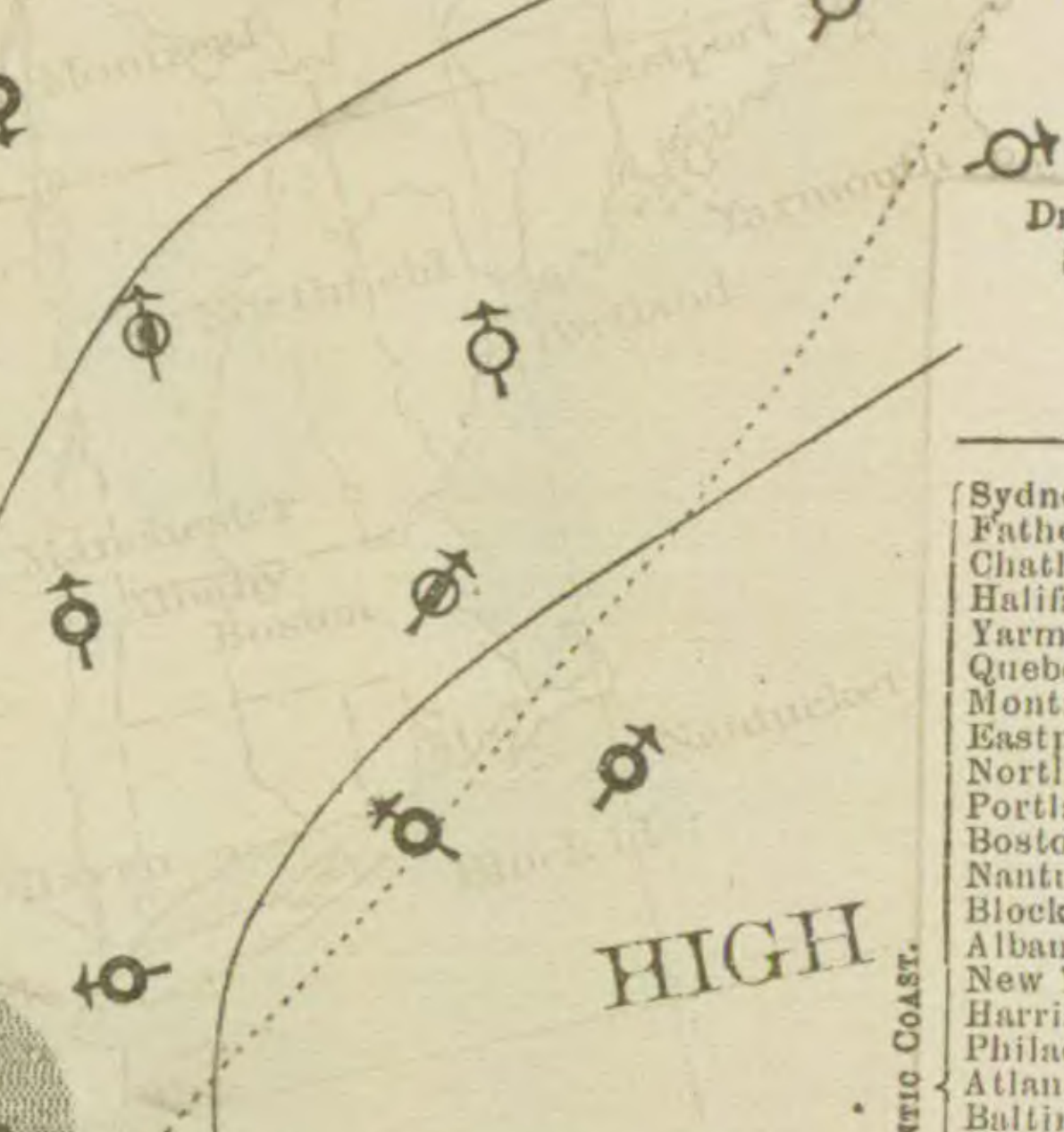
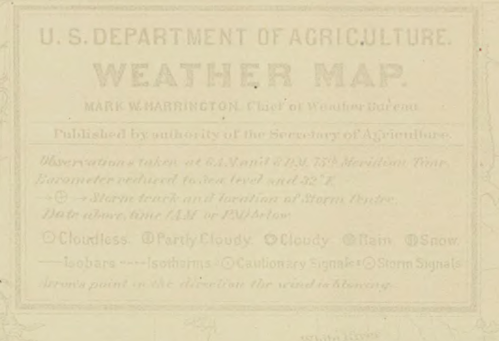
Block Island’s open ring is the legend’s “Cloudless” mark, like Nantucket’s; Boston’s ring is barred. This symbol is a descriptive category, not a measurement. Compare the legend at 8×. The printed rainfall column gives 0 inches over the preceding 24 hours. That does not establish rainfall or cloud at Stonington at 5 a.m.

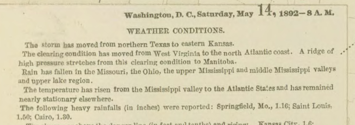
The map’s regional note says: “The clearing condition has moved from West Virginia to the north Atlantic coast.” It describes a region, not the painting site.
Computed · Eastern Standard Time · P3
If five meant standard time
4:29 sunrise, a.m.
4.5° sun’s altitude at five
Civil dawn (sun 6° below the horizon) about 3:58 a.m. Sun’s azimuth at five: 68.8° clockwise from true north, towards the east-northeast.
Five a.m. corresponds to 10:00 Universal Time, about 31 minutes after calculated sunrise. The weather map is three hours later.
Computed · Local mean time · P3
If five meant Stonington time
4:42 sunrise, a.m.
2.3° sun’s altitude at five
Civil dawn about 4:10 a.m. Sun’s azimuth at five: 66.8° clockwise from true north, towards the east-northeast.
At the assumed longitude, local mean time runs about 12 minutes ahead of standard time. Five corresponds to about 09:48 Universal Time, about 18 minutes after calculated sunrise. The map is about three hours twelve minutes later.
The assumptions behind the numbers
NOAA Solar Calculator equations based on Jean Meeus, re-implemented by Nephos in Python. Assumed Stonington position: 41.34° N, 71.91° W. This is a town location, not a known easel position.
Altitude is the geometric height of the sun’s centre. Sunrise uses a centre altitude of −0.833° for standard refraction and the solar radius, with a level, unobstructed horizon. Civil dawn uses −6°. Times are rounded to the nearest minute.
Clouds and the local horizon can delay visible sunlight. The unavailable reanalysis mean and spread are left out. Calculation receipt · Reproduce it.
03 · Making the artwork
What this record cannot see.
The museum’s information identifies the work. The sources assembled here do not establish every stage of its making.
- Date evidencetitle and inscription
- The date and hour come from the title as given by the curator, 17 September 2026, when asked for a work dated to the day. P1 They are also inscribed on the front, lower right, in what the curator understands to be Perry’s hand; her photographs show “Stonington May 14 1892 5 AM”. P6 P7 The collection page remained unreachable.
- Clockunresolved
- The supplied title does not say whether Perry used Eastern Standard Time or local mean time. Both are calculated; neither is assigned to him as a fact. P3
- Weather at the sitenot observed here
- The nearest located map observation is on Block Island, about 35 km away and later that morning. Its instrument position in 1892 is unverified; the distance uses later station coordinates only to locate the island approximately. Coastal conditions at Stonington may have differed. P2 P4
- Outdoor execution and later changesunknown
- The supplied information does not establish the exact easel location, direction of view, duration of work, preparatory studies or later alterations. Unknown does not mean none occurred. No museum description of the scene was available, and no image has been reproduced, described or measured by Nephos. P1
04 · Revisions
How this record was assembled.
Object information, historical observation and calculation retain separate sources.
- New evidence
- The curator wrote on 25 September, with a second photograph: “As you can see in the attached photo, AM is visible after the 5.” P7 Nephos’s reading had stopped at the “5”.
- What changed
- The inscription now reads “Stonington May 14 1892 5 AM”, agreeing with the title’s “5am”. The verdicts are unchanged: the hour is still the painter’s own statement, tested against the computed sunrise.
- New evidence
- The curator wrote on 21 September that the inscription is on the front, lower right, and that she understands it to be in Perry’s hand, and sent a photograph. Nephos transcribed it from the photograph, stopping at the “5” (corrected 25 September). P6
- What changed
- The place and date explanations now cite the inscription. The verdicts are unchanged: an inscription is the painter’s own statement of the date, not an independent record that the painting was made that day.
- Object information
- The curator’s supplied title and catalogue fields are retained verbatim. The object page could not be checked. P1
- Evidence added
- The Weather Bureau morning map was opened and its Block Island row and legend read. Solar context was computed under two clock conventions. P2 P3
- Conclusion now
- Daylight was possible at five under either clock. The weather at Stonington at that hour remains unknown. There is no claim about the painted sky.
- Retained sources
- Curator-supplied text Map transcription Source retrieval log
05 · Take this into your work
A record you can cite, print or embed.
Cite individual claims by their links and cite the museum and historical sources directly when using their statements. The title is supplied by the curator; the weather interpretation and calculations are Nephos analysis.
Machine-readable
For the Florence Griswold Museum: this record is for 2017.1.3. If it is right, link it from your object page; if anything is wrong, write to Nephos and it will be corrected the same day.
The museum’s catalogue remains the authority. Nephos does not claim endorsement.
06 · Sources
Follow every claim.
- P1Amy Kurtz Lansing, Curator, Florence Griswold Museum, communication to Vedang Sharma, 17 September 2026. Verbatim supplied text and object fields. The communication is not a public web source; the public catalogue could not be opened, and its additional fields remain unverified.http://collections.flogris.org/objects-1/info/22780
- P2U.S. Department of Agriculture, Weather Bureau, Weather Map, 14 May 1892, 8 A.M., first PDF page. Block Island row in the Atlantic Coast table, including “Temperature. Minimum.”, “Pressure. Readings in inches.” and “Pressure. Change in 12 hours.”; Block Island’s open-ring symbol, the coastal “HIGH” label and central legend; regional text at lower left. Federal publication, public domain. NWS reuse policy.Open the original map · Transcription · Table crop · Pressure headings · Station symbols · Legend · Regional note
- P3NOAA Solar Calculator, equations based on Jean Meeus, Astronomical Algorithms. Re-implemented by Nephos in Python, with a full Gregorian Julian-day calculation, two clock offsets and a level-horizon assumption. An independent JPL Horizons query agrees within 0.01° at the checked morning times; neither calculation supplies cloud conditions.Method and limitations · NOAA equations · Reproducible computation · Independent calculation check and query URL
- P4NOAA GHCN-Daily station list: Block Island coordinates 41.1667° N, 71.5667° W, used only as an approximate island location. Great-circle distance from the assumed Stonington point is 34.6 km, reported as about 35 km; the historical instrument position is not established.Station list · Retained row · Distance inputs and method
- P5U.S. Department of Agriculture, Weather Bureau, Weather Map, 13 May 1892, 8 P.M., second PDF page. Block Island’s barometer reads 30.36 inches under “Pressure. Readings in inches.” The rise to 30.44 on the next morning’s map is 0.08 inch, confirming that its “+ 8” change is in hundredths of an inch.Open the preceding evening’s map · Table crop · Date and hour
- P6Amy Kurtz Lansing, Curator, Florence Griswold Museum, communication to Vedang Sharma, 21 September 2026, with a photograph of the painting: “I have attached a photo of the painting, with the inscription visible at lower right. I have understood the inscription to be in the artist’s hand.” The photograph is not reproduced; no reuse licence has been verified. The words “Stonington May 14 1892 5 AM” are Nephos’s reading of it and of a second photograph (P7), not a museum transcription. Inscription fields
- P7Amy Kurtz Lansing, Curator, Florence Griswold Museum, communication to Vedang Sharma, 25 September 2026, with a second photograph of the inscription: “One small correction for use in editing your post. As you can see in the attached photo, AM is visible after the 5.” The photograph is not reproduced. Inscription fields