No open image licence has been established for this painting.
A study against the weather record
Georgia O’Keeffe
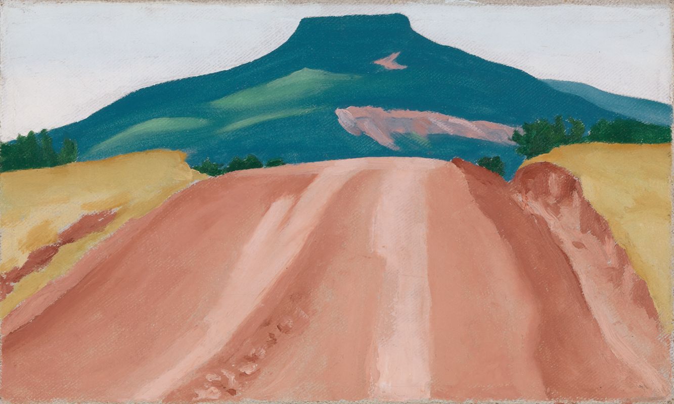
Road to Pedernal
A dry-looking road in New Mexico’s wettest recorded year. The station record and O’Keeffe’s rain letters test what this open view leaves out.
Exceptionally wet seasonPainted day unknown
The Nephos method
How this study was read
The method in fullWhat is written
The museum dates the oil to 1941; the documented visit spans May–November, with excursions. O’Keeffe’s letters to Henwar Rodakiewicz describe rain in July, September and October, including a lost view of the mountain. None names this canvas.
Oh it has rained and rained today -- we have no mountain and the cliffs have us lost.
O’Keeffe to Henwar Rodakiewicz; Library of Congress, October 1941, box 1 folder 17, image 5
Records of those days
- Nephos’s visual readingA broad, dry-looking pink-red dirt road runs towards Cerro Pedernal, between pale yellow-ochre fields, below a teal-blue mesa and a white sky: a dry, bright scene with no visible puddles or wet sheen. Green trees and green passages on the mesa are visible; the fields are not lush green. White paint does not distinguish sun, overcast or haze, and apparent dryness is not a soil-moisture measurement.
- NOAA New Mexico annual precipitation1941: 26.57 inches, rank 1 of 131, 1895–2025. Statewide, not a ranch gauge.
- El Rito, Abiquiu, Española, Santa Fe city and airportSeparate monthly archives; same-calendar-month ranks use every accepted total through 2025. Only El Rito has all seven usable 1941 months. The city’s unexplained summer zeros are excluded.
- El Rito 1991–2020 normalsMay–November: 210.3 mm. NOAA’s S/R completeness flags and observed year counts are retained; provider estimates fill some missing months.
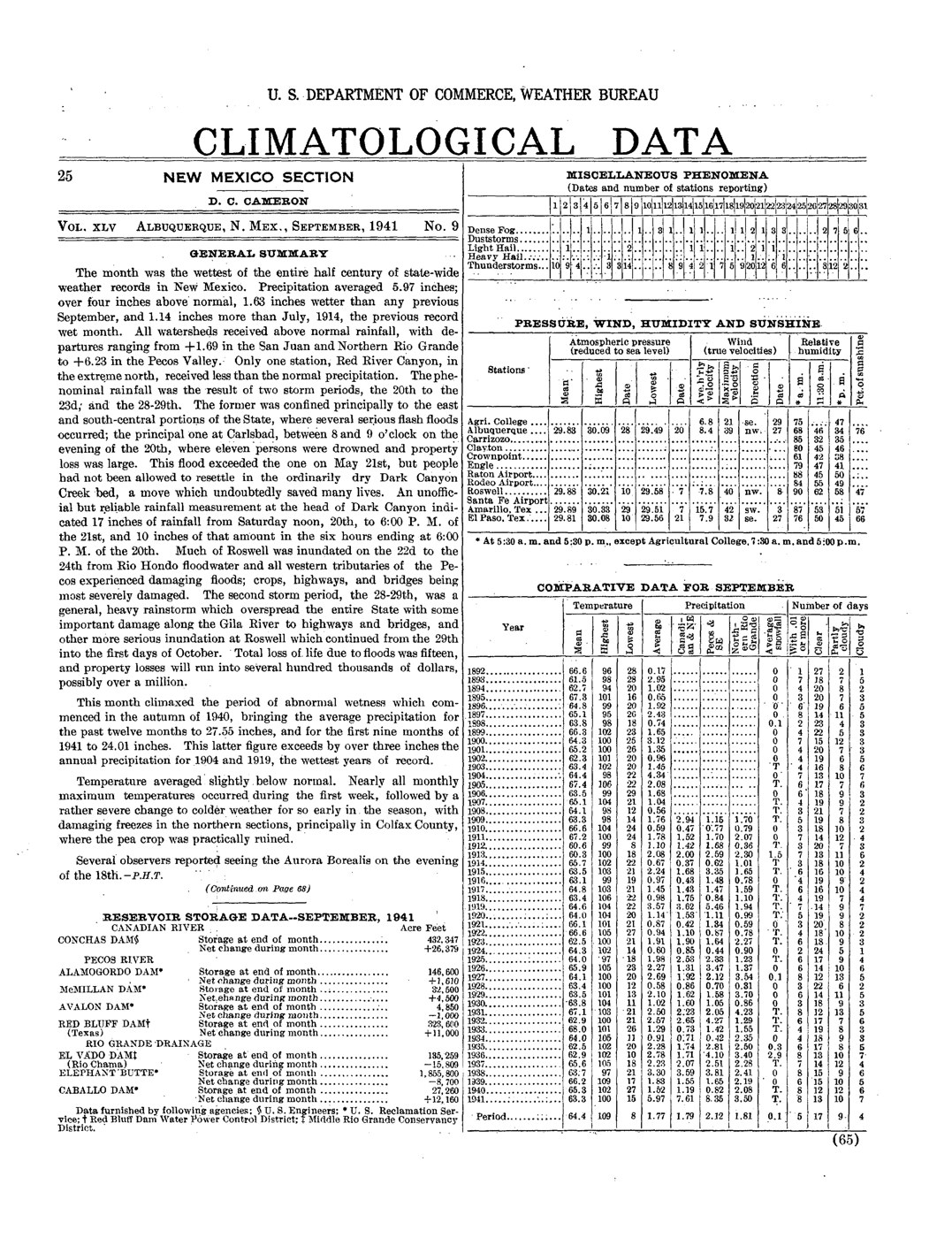
- Contemporary letters and Weather Bureau reportShort letter excerpts re-read against manuscript images. The September report describes statewide wetness and flooding elsewhere in New Mexico, not a washout on the painted road.
Not found or not yet searched
- The year and visit months do not date a painting session. The precise viewpoint is not established.
- Abiquiu begins after 1941. Española lacks May and October; Santa Fe Airport begins in June.
- The tested Library of Congress collection has no digitized Santa Fe New Mexican pages for 1941; other holdings may survive.
- The related graphite drawing does not establish order of making, a studio sequence or a change in observed weather.
Each claim tested
- Does the dry-looking road describe a generally dry visit season? No at El Rito: 381.0 mm ranks first of 45 usable May–November seasons, spanning 1934–2008. May, September and October are near the wet end of their monthly records. August and November are below their modern normals.
- Could a rainless interval coexist with the exceptionally wet season? The El Rito archive has 5 consecutive unflagged zeros, 1941-10-31–1941-11-04. Traces, P entries, quality flags and missing days interrupt the strict test. This permits a rainless interval at a regional gauge; neither a painted date nor road drying time follows.
- Does the record establish that O’Keeffe deliberately removed rain? No. The picture presents an open view while an October letter says rain hid the mountain. The sources do not connect that letter to the canvas or establish a weather alteration.
Verdict
Nephos reads a dry-looking road and a clearly visible mountain in a wet year. El Rito’s May–November 1941 total is 381.0 mm, first among 45 usable seven-month seasons and 1.81 times its 1991–2020 normal. O’Keeffe’s rain letters make the contrast local to her experience; daily zero runs permit rainless intervals without identifying the painted day or proving she changed observed weather.
- Partially agreesAn exceptionally wet regional season Statewide NOAA ranking, El Rito monthly comparison and contemporary rain letters concur, at their different scales.
- UnknownA specific painted day or a deliberate change to observed weather A zero run cannot date the painting; the letters do not name it.
What this cannot tell you. The visual reading is Nephos’s, not a museum statement. Green trees and mesa passages are visible; the sky’s whiteness is not a cloud diagnosis. Ranks describe an incomplete, unhomogenized archive; missing seasons are excluded. Monthly GSOM totals can include daily presumed-zero encodings. Daily unflagged zeros are an archive classification, not independently verified dry ground; the printed tables do not resolve all zero flags. Station coordinates are modern catalogue positions. Distances to a ranch reference do not identify a gauge-to-easel relationship. Modern normals include NOAA gap estimates. No new cross-station average or climate-trend attribution is made. The letters’ months are archival dates; artist-authored testimony is not independent of the artist’s work. Artwork and letter images were inspected internally and are not reproduced. Short quotations and the public-domain weather report carry the evidence. Research and transcription checks were performed by one owner; no independent second reader is claimed.
Step 1 · Begin with the picture
A dry road in New Mexico’s wettest year
Nephos’s reading of the picture, not a museum statement: A broad, dry-looking pink-red dirt road runs towards Cerro Pedernal, between pale yellow-ochre fields, below a teal-blue mesa and a white sky: a dry, bright scene with no visible puddles or wet sheen. The broad road dominates the foreground; its pale wheel tracks have no visible reflections, and the bordering fields are yellow rather than lush green. Green trees and green passages on the mesa remain visible. This is a reading of depicted surfaces, not a diagnosis of drought or a claim that the white sky must be sunny.
That reading makes a test possible: was the season generally dry, or has O’Keeffe given a dry-looking form to a landscape she encountered in an exceptionally wet year? The distinction matters because a picture can select a moment or simplify a view without summarizing a season.
NOAA’s National Weather Service identifies 1941 as New Mexico’s wettest year. The current statewide annual series confirms it: 26.57 inches, first of 131 years, 1895–2025. A statewide average is not rain on this road. The next test therefore moves to the individual station records.
The museum dates the oil to 1941, without a month or day. The Library of Congress chronology places O’Keeffe at Ghost Ranch in May–November; the museum chronology also records excursions elsewhere. The comparison uses those whole calendar months, including uncertain arrival and departure days. They date the visit envelope, not work on this particular canvas.
Step 2 · The season against the long record
The wetness came in pulses
At El Rito, about 25 km from the Ghost Ranch reference point, the May–November total is 381.0 mm in NOAA’s monthly archive. It is the highest of 45 seasons with all seven usable monthly totals, spanning 1934–2008. The monthly archive was searched through its 2022 endpoint; gaps exclude the other seasons. This is a rank within the available record, not proof against every missing year.
The season received 1.81 times the 1991–2020 normal of 210.3 mm. May, September and October sit near the wet end of their monthly records. August and November are below their modern normals. A wet year was not continuous wet weather.
El Rito: every 1941 month, rank and modern comparison
| Month | 1941 | Rank / years | 1991–2020 | Ratio | Normal coverage |
|---|---|---|---|---|---|
| May | 70.0 | 2 / 86 | 22.4 | 3.13× | S; 25 years |
| June | 54.4 | 7 / 82 | 18.8 | 2.89× | R; 23 years |
| July | 52.4 | 22 / 76 | 45.0 | 1.17× | R; 21 years |
| August | 43.0 | 40 / 75 | 48.3 | 0.89× | R; 23 years |
| September | 78.9 | 3 / 76 | 38.1 | 2.07× | R; 20 years |
| October | 75.5 | 3 / 78 | 21.6 | 3.50× | R; 20 years |
| November | 6.8 | 49 / 71 | 16.3 | 0.42× | R; 18 years |
The monthly archive is a NOAA summary of daily data. The comparison rejects monthly totals carrying missing-day, accumulation or quality flags. It does not turn the daily archive’s presumed-zero entries into observed dry days. The original Weather Bureau totals sum to 14.98 inches (380.5 mm); the monthly digital total is 381.0 mm because daily inch-to-millimetre conversions were rounded individually. The builder checks this small difference against the scans.
The modern comparison uses NOAA’s published station normals, including its documented gap estimates. It compares the same calendar season at one named station. It is not a measurement of climate change at Ghost Ranch.
Step 2 · Check each place separately
The statewide record does not describe every gauge
The northern records support a wet autumn, with important gaps and differences. Española and both Santa Fe stations recorded substantial September precipitation. Santa Fe Airport’s July and August sit much lower in their own rankings. No station is averaged into another, and the airport is never substituted silently for the city.
| Station | May | June | July | August | September | October | November |
|---|---|---|---|---|---|---|---|
| El Rito | 70.0 2 / 86 | 54.4 7 / 82 | 52.4 22 / 76 | 43.0 40 / 75 | 78.9 3 / 76 | 75.5 3 / 78 | 6.8 49 / 71 |
| Abiquiu | No record | No record | No record | No record | No record | No record | No record |
| Española | No record | 18.5 30 / 90 | 43.0 27 / 80 | 44.0 33 / 84 | 64.3 4 / 82 | No record | 13.5 26 / 86 |
| Santa Fe city | 56.0 19 / 104 | Excluded zeros | Excluded zeros | Excluded zeros | 73.2 14 / 107 | 69.9 8 / 105 | 13.5 56 / 106 |
| Santa Fe Airport | No record | 38.1 7 / 44 | 30.7 30 / 45 | 26.4 35 / 44 | 69.9 4 / 45 | 69.0 5 / 42 | 9.2 16 / 44 |
Abiquiu’s series begins in 1942; it cannot test 1941. Española lacks May and October. Santa Fe Airport starts in June 1941. The city file’s June–August zeros are excluded because their provenance is unresolved and the inspected summer reports list the airport instead. None supplies a complete May–November total for 1941, so only El Rito receives a seasonal rank.
Catalogue-coordinate distances to the ranch reference are 32 km for Abiquiu, 53 km for Española, 89 km for Santa Fe city and 88 km for the airport. They cross different terrain and elevations. Neither the 1941 gauge positions nor the precise painted viewpoint are established by those modern coordinates.
Step 3 · The artist’s weather and the daily record
“we have no mountain”
O’Keeffe’s letters to filmmaker Henwar Rodakiewicz put rain inside her own experience of that season. In July she described a wet night and work to stop her house leaking. In September she mentioned warm days and rain in the same letter. In October, rain erased the mountain from her view.
“It rained almost all afternoon”
O’Keeffe to Henwar Rodakiewicz; Library of Congress, July 1941, box 1 folder 16, image 3
“Warm lovely days”
O’Keeffe to Henwar Rodakiewicz; Library of Congress, September 1941, box 1 folder 16, image 8
“Today it rains and I have a fire”
O’Keeffe to Henwar Rodakiewicz; Library of Congress, September 1941, box 1 folder 16, image 8
“Oh it has rained and rained today -- we have no mountain and the cliffs have us lost.”
O’Keeffe to Henwar Rodakiewicz; Library of Congress, October 1941, box 1 folder 17, image 5
These short excerpts were checked against the Library of Congress manuscript images. The letters are assigned to months, not exact days, and none names this canvas. They are artist-authored testimony, not an independent test of her picture. Even so, the contrast is specific: the letter loses the mountain; the painting gives Pedernal a firm, uninterrupted silhouette.
Could a break in the rain fit a dry-looking road? The El Rito digital file contains 5 consecutive unflagged zeros, 31 October–4 November 1941. Santa Fe Airport has 12, 1 November–12 November 1941. Those archive runs fall within the documented visit months. They make a rainless interval compatible with the record; neither is proposed as the painting’s date.
The stricter test ends a run at a trace, a missing day, a quality flag or a P flag (missing, presumed zero). If P entries were accepted as zero, El Rito’s longest run would extend to 13 days, 31 October–12 November 1941, but 8 of those entries are presumed. That extension is a sensitivity calculation, not a verified dry spell. The printed tables do not independently confirm the digital distinction between unflagged and presumed zeros. No drying time is estimated for the road: its soil, drainage and actual weather are unmeasured.
The Weather Bureau’s September report records exceptional statewide wetness and damage to highways and bridges in the Pecos and Gila regions. Those flood accounts are not reports of this road washing out. A tested Library of Congress search returns no digitized 1941 pages for the Santa Fe New Mexican; that is an online coverage gap, not a claim that no newspaper witness survives.
“The month was the wettest of the entire half century of state-wide weather records in New Mexico.”
U.S. Weather Bureau, September 1941, General Summary, printed p. 65 / PDF p. 1; statewide claim as published then
Read the contemporary September weather report
Step 4 · What O’Keeffe chose
An open view, not a seasonal average
The test rejects a generally dry season at El Rito as the explanation for the picture’s dryness. The year was extraordinarily wet; the artist herself wrote about rain hiding the mountain. Yet the painting presents a bare, dry-looking road and a clearly visible Pedernal. That is the useful curatorial tension: the picture’s chosen appearance leaves out the rain’s obscuring presence recorded in her letters.
It does not follow that she removed rain from an observed scene. The daily record and her description of warm, lovely days allow breaks in the wet weather. A dry interval, an earlier remembered view or a simplified composition remain possible; the surviving evidence does not choose among them.
The museum also holds a related graphite sheet, Untitled (Road to Pedernal), CR 1019, alongside this oil, CR 1020. The catalogue connects their images but does not establish their order. The coloured oil makes the road, fields and mesa distinct broad planes. That compositional choice is visible; a field-sketch-to-studio sequence or a deliberate weather alteration is not documented for this canvas.
Limits that remain: a year-dated picture; a visit envelope with excursions; regional, incomplete, unhomogenized station records; normals with estimated gaps; no local soil-moisture or sky observation; no exact painting day. The visual reading belongs to Nephos. The weather and letters give it a testable historical setting, not a certificate of meteorological fidelity.
Sources
Every source on this page
Each file was downloaded and given a fingerprint (its sha256). The page is rebuilt from these files and will not build if a fingerprint changes, so every number above comes from them rather than being typed in.
- NOAA GHCN-Daily stations
sha256 14c6467fcce6cce8dc0786eba8bbceed51a2f1c1056b0e221b573157559fc824 - NOAA GHCN-Daily inventory
sha256 fb8a5b7b5bd25b6828fc822e4a4bc2a036053ac5af30697b4df1386a21cb0e59 - NOAA GHCN-Daily readme
sha256 0e4e6f0e6947cf1add884c328a01760f31c56ef5fb86b85ed57dd5dc4c4aeaa6 - NOAA GHCN-Daily USC00292820 / el-rito
sha256 e0d335d976cbfc6df39a0a4dabe813667af26c72c952100435b3ea5a2f4a70e1 - NOAA GHCN-Daily USC00293031 / espanola
sha256 5554c9d4062db88dbd9c318a0b9e78ec8cb07b3330ac833ab868c063b3bec1e5 - NOAA GHCN-Daily USC00298072 / santa-fe
sha256 29640cceeb8bd12a2e46dc7e7334c66456f12f08b79651b38961871f9e77c49a - NOAA GHCN-Daily USC00296028 / nambe
sha256 9597b86c1df139e3117f39fe76f256e61dda8fbf46ffcabe2c61291d8f63af3d - Museum object record, CR 1020 / 2006.5.170
sha256 a58ac17e3d2e150aaa4ebd40e0369d0c9d000115c3b40bfb9eac493a6660ddae - Museum graphite drawing, CR 1019 / 2006.5.169
sha256 fc92d84ad0a4a03a7fc7d1bc791f24c5db4a0c6e9e9592890623ac7bd0e9bc92 - Museum catalogue raisonné chronology, adapted from Lynes (1999)
sha256 4f99d3cca1042c06f350012899f720a26b07622582228b897e9e2f2a4c5c683e - Library of Congress, Georgia O’Keeffe timeline
sha256 22c7e00922a0e132a8905ba54d95b6e8bdeabfad10cac64bfd2768c6178a5b9c - OpenStreetMap Ghost Ranch reference
sha256 30fb91b9857d2ad2a8a43356c4cb4d867c2241f7c338287fe7b6a65b0a9be424 - U.S. Weather Bureau, New Mexico, 1941-11
sha256 fa2eca6ed9fdae987b1659c3cf1643023da668e97b042de06e90f8100b391d36 - U.S. Weather Bureau, New Mexico, 1941-10
sha256 e962a412504c2d1094cc3567bd181e344782fdf7a35f341cab4701bdff68cbf7 - U.S. Weather Bureau, New Mexico, 1941-08
sha256 6f59dd8c53089183e211ac09ccb14d46f0947680b24bb197c730b9c0662c0d26 - U.S. Weather Bureau, New Mexico, 1941-06
sha256 9e3d8f8cf5b95990fc650b29aeb2cace513546526bef71756a64fc881b2ba5b1 - U.S. Weather Bureau, New Mexico, 1941-07
sha256 5a0fbf8023dae7f05fd8aab60de28473cb801ac1535d99718de071de6aa79ae6 - U.S. Weather Bureau, New Mexico, 1941-09
sha256 ffd89a6ec86ef03cb69d00611231dc130393e317573bd79064f86e87327b9e86 - U.S. Weather Bureau, New Mexico, 1941-05
sha256 52f91820a8aa13bd06555e4ea075d4b440a4a839b9563b6f07e20ff9c660088e - Nephos transcription of Weather Bureau tables
sha256 62784fa5a94276d44abdcc0f33ed7bf784ef9e61d47f1742d30bac665afd5d85 - NOAA Climatological Data publication collection
sha256 f86815ecb585eae84fa63767f90b000f6156dd64da65407ffb018325cf2dee77 - NOAA Climate at a Glance: New Mexico annual precipitation
sha256 bff781cce1395fd8433f9fc69d9ff85ee1c0f2e969073d018237a733bbc63cfc - National Weather Service Albuquerque: 1941 extreme precipitation
sha256 539b131aea48c11f73ac0a71e908e07a4e9bbaee05dedf97b15c6fec417f2ac1 - NOAA Global Summary of the Month documentation, v1.0.3
sha256 35facf144e7be52a71a557cccfe7660dd60d7b3fded91cfa2f28e854898c860c - NOAA 1991–2020 monthly normals documentation
sha256 b12c9aee6770f84b5fa902740413bffca5cbf9a83bbebcf7e73306f46168ffc6 - NOAA GHCN-Daily: Santa Fe Airport, USW00023049
sha256 03a9f0ba2ed43e53cbdf2965c1cb04dc30eeb3797ffc9be7fc8ac768528ae9d3 - Georgia O’Keeffe to Henwar Rodakiewicz, July–September 1941
sha256 560282b21101447c56402b16adc66b4f43e2a94b75d1ff1546aefe7d22f59826 - Georgia O’Keeffe to Henwar Rodakiewicz, October 1941
sha256 24eda65c348d3d95af7bb66e389272217d8791ca2627762e17c814df7c780273 - Library of Congress: July 1941 letter manuscript
sha256 1decdfcd78399733d5260d951922dbd0bb5094285862577517edd91e6809dab8 - Library of Congress: September 1941 letter manuscript
sha256 f87ddaea2f1e98884d27eb32176850660edffce8b875097cfb3ae6449c84ae6e - Library of Congress: October 1941 letter manuscript
sha256 e7cf861be209dd9fd19a68f181e5d9a3d01a8e12c0fb3b82c7935f024b95fb6e - Library of Congress: Santa Fe New Mexican page search, 1901
sha256 35844cdfa97451bcae86179c94bbba8daf361fa462eb0852dd047656e3b61661 - Library of Congress: Santa Fe New Mexican page search, 1941
sha256 2546e156f5d039c3d5d49a08ec406576a1a7b95e35e5875a70691bdb1054c818 - NOAA monthly precipitation archive: el-rito
sha256 3814c53936cbd4b6dd8944d3c1512bc7bcdcceb478826125a00bc8f7e19608f6 - NOAA monthly precipitation archive: espanola
sha256 4b50c83bb3893c7b8995f0d37be6a83bbde3fe579000fcc73f8db979151ddc0e - NOAA monthly precipitation archive: santa-fe-city
sha256 905abb6936fe69388fa9c9d299fd02fcf14e1c7a3955ee2e3b6d7e2783e9136f - NOAA monthly precipitation archive: santa-fe-airport
sha256 98c54cd5f37fb2683e32d3727962efe1395fbe9cf840c60b109341bfcb7a3294 - NOAA monthly precipitation archive: abiquiu
sha256 6456b26425b3045087f8fa4381f27102ac10ec90eac371148863c546d7943e79 - NOAA 1991–2020 precipitation normals: el-rito
sha256 0ded885071f1ba1a52298a8ef68f0927bd51bfd058288c8675bef650e6ac7415 - NOAA 1991–2020 precipitation normals: santa-fe-airport
sha256 fa70ebdd8287e51e75eb56b8801b0156492a38cc8b56a3ef85d395dbe585987a - Georgia O’Keeffe Museum: Road to Pedernal reference image
sha256 f022ffe634693e7f9a7b1d5886df1e09ce299b47f98f4fd5a1dcfbe61e08d909 - T120 scan cross-check: Española, Santa Fe city and airport
sha256 32b7d3814d05b26c2cae69fa3bb9357c5d3fbce34b143eff5f8df15565a3c334